


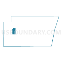
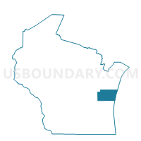
CATO - T 2 Voting District, Manitowoc County, Wisconsin
About
Outline

Summary
| Unique Area Identifier | 694700 |
| Name | CATO - T 2 Voting District |
| County | Manitowoc County |
| State | Wisconsin |
| Area (square miles) | 16.63 |
| Land Area (square miles) | 16.46 |
| Water Area (square miles) | 0.17 |
| % of Land Area | 98.96 |
| % of Water Area | 1.04 |
| Latitude of the Internal Point | 44.11589240 |
| Longtitude of the Internal Point | -87.83120810 |
Maps

Graphs
Select a template below for downloading or customizing gragh for CATO - T 2 Voting District, Manitowoc County, Wisconsin


Neighbors
Neighoring Voting District (by Name) Neighboring Voting District on the Map
- CATO - T 1 Voting District, Manitowoc County, WI
- FRANKLIN - T 1 Voting District, Manitowoc County, WI
- FRANKLIN - T 2 Voting District, Manitowoc County, WI
- KOSSUTH - T 2 Voting District, Manitowoc County, WI
- LIBERTY - T 1 Voting District, Manitowoc County, WI
- LIBERTY - T 2 Voting District, Manitowoc County, WI
- MANITOWOC RAPIDS - T 1 Voting District, Manitowoc County, WI
- MANITOWOC RAPIDS - T 4 Voting District, Manitowoc County, WI
- NEWTON - T 4 Voting District, Manitowoc County, WI
- Whitelaw - V 1 Voting District, Manitowoc County, WI
Top 10 Neighboring County Subdivision (by Population) Neighboring County Subdivision on the Map
- Newton town, Manitowoc County, WI (2,264)
- Manitowoc Rapids town, Manitowoc County, WI (2,150)
- Kossuth town, Manitowoc County, WI (2,090)
- Cato town, Manitowoc County, WI (1,566)
- Liberty town, Manitowoc County, WI (1,281)
- Franklin town, Manitowoc County, WI (1,264)
- Whitelaw village, Manitowoc County, WI (757)
Top 10 Neighboring Place (by Population) Neighboring Place on the Map
Top 10 Neighboring Unified School District (by Population) Neighboring Unified School District on the Map
Top 10 Neighboring State Legislative District Lower Chamber (by Population) Neighboring State Legislative District Lower Chamber on the Map
Top 10 Neighboring State Legislative District Upper Chamber (by Population) Neighboring State Legislative District Upper Chamber on the Map
Top 10 Neighboring 111th Congressional District (by Population) Neighboring 111th Congressional District on the Map
Top 10 Neighboring Census Tract (by Population) Neighboring Census Tract on the Map
- Census Tract 104, Manitowoc County, WI (6,182)
- Census Tract 102, Manitowoc County, WI (5,891)
- Census Tract 103, Manitowoc County, WI (4,493)
- Census Tract 105, Manitowoc County, WI (3,636)